 * Image source/ caption*
same as the original article below
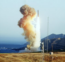
‘An official dealing with North Korea’s projected satellite launch looks at a map of the rocket’s potential drop zone at the Foreign Ministry in Seoul on March 13.’
http://english.hani.co.kr/arti/english_edition/e_northkorea/344109.html
North releases details of rocket’s flight path Diplomatic and technical calculations are at play with the designated drop zone near Japan and not the U.S. Posted on : Mar.14,2009 11:49 KST
After the North notified the International Civil Aviation Organization and International Maritime Organization of its plans to launch a communications satellite early next month, it released the details of the multi-stage rocket’s flight path. According to Pyongyang, the first stage would first splash into East Sea, 650 kilometers away from the launch pad at Musudan-ri, with the second stage falling into the Pacific, 3,600 kilometers from the East Sea.
Missile experts and Seoul government officials say that the rocket that the North will launch on April 4-8 will fly for 125 seconds at an altitude of 50-60 kilometers before the first stage falls into the East Sea. The second stage is expected to fly at an altitude of 130-150 kilometers for 125 seconds before falling into the Pacific. The margin of error for the drop zone is 100-150 kilometers.
The rocket’s estimated flying range is much longer than that of the Kwangmyongsong-1, better known as the Taepodong-1, which the North launched in August 1998. The rocket’s first stage flew 253 kilometers before it hit the sea and the second stage fell 1,646 kilometers from the launch site.
The rocket to be launched next month is expected to have a longer flying range than the Kwangmyongsong-1 because it is larger in diameter and height and can carry a greater amount of fuel, a researcher at the Korea Aerospace Research Institute said.
Kwangmyongsong-1 was reportedly 28.1 meters long and weighed 19.9 tons. Sources say that the rocket to be launched next month will be over 40 meters long.
The rocket’s trajectory is largely determined based on scientific and technological conditions but the position of neighboring countries is also a factor. Generally, a rocket is launched eastward at an angle of 90 degrees in order to make the most of the earth’s rotation. In 1998, the North fired the Kwangmyongsong-1 at an angle of 86 degrees eastward between Sakhalin, Russia, and Hokkaido, Japan. At the time, the North explained that it had adjusted the firing angle for safety reasons, saying that if the rocket were launched at an angle of 90 degrees, it would spend more time over Japan and the second stage could fall into Japan’s territorial waters.
Based on the North’s announcement and explanations, the rocket launched next month will be launched at an angle of 90.5 degrees, meaning it will have a 0.5 degree westward tilt. This will give it a longer flight path over Japan, in comparison with the Kwangmyongsong-1. One aerospace expert said, “If the angle is adjusted to 86 degrees as it was with Kwangmyongsong-1, it is likely that the rocket’s second stage will fall into the Pacific Ocean off of Hawaii.” This indicates that Pyongyang has decided to avoid inciting the United States, choosing instead to risk criticism from Japan.
The South Korean government, meanwhile, is taking special precautions for airplane safety. The Ministry of Land, Transport and Maritime Affairs said that the rocket is expected to fall 90 kilometers away from the Kamchatka air route and 370 kilometers away from the Pacific route. “Airplanes using the Kamchatka route should take extra precautions, including the monitoring of wind directions. The Pacific route will be adjusted by the U.S. in charge of flight control to avoid the drop zone.”
Please direct questions or comments to [englishhani@hani.co.kr]
© 2006 The Hankyoreh Media Company.
* Related news*
http://www.defensenews.com/story.php?i=3988364&c=ASI&s=TOP
S. Korea Warns North of U.N. Action over Rocket Launch
By SIMON MARTIN, Agence France-Presse
Published: 13 Mar 09:35 EDT (13:35 GMT)
‘SEOUL, March 13, 2009 (AFP) - South Korea warned Friday of United Nations "countermeasures" after North Korea set dates for a satellite launch seen by Seoul and Washington as a disguised test of a missile which could reach Alaska.
U.S. President Barack Obama also spoke of the "risks" posed by Pyongyang's missile plans, while U.N. Secretary General Ban Ki-moon said the launch "will threaten peace and security in the region."’
* Related Korean article*
http://www.tongilnews.com/news/articleView.html?idxno=83302
![[URGENT PLEA: In Update] EMERGENCY in GANGJEONG Since AUG. 24, 2011](https://blogger.googleusercontent.com/img/b/R29vZ2xl/AVvXsEiQvpaNf6EePZVucu97_JphYsFS5IgumnSiA4YAmen1PZcim6vMmW7XjZ7J6nLh-Cu36mwBN5n1evrA3ey0vYMpwlAGsgnSFggv6a1w4Qx9BvvqOB0hy0BIcBkL2Exfs3zIxBsBuDGa1kzg/s227/jejusit.jpg)


![[Solidarity from Japan for the Jeju] 253 individuals and 16 groups/organizations](https://blogger.googleusercontent.com/img/b/R29vZ2xl/AVvXsEivji7100kBkr0hzvqYfh4IBBilkZ6XgDIg89jOxS6kTssxsVKC6Wm-fZbKOEsiy3zcO-9gW6GHspD5R_2C9WsGx5S1Z5VPj_OVRF7H6dxdaT0S-2H1eqsDsYvIwOV26VscxTHnKmP5iZmh/s227/jeju_12_10j.jpg)

![[Translation] Korean organizations' statement: Immediately cancel the joint ROK-US drill Nov 26](https://blogger.googleusercontent.com/img/b/R29vZ2xl/AVvXsEgfKDMo-qyEjm5asUtHlREyJY_5Ou-2tyB8SH6aUxiViRbbKR-8W_rirFiGp5DYSoD_KaeNOPMWR0af0ZPUIbJKmR89ImDvADHsGAIqsJVBvJNBEIl5wLd3G_zhPDW3Z2SxsHXadOsXe8st/s227/1.jpg)
![HOT! [Hankyoreh Hani TV] Beneath the Surface: the investigation into the sinking of the Cheonan](https://blogger.googleusercontent.com/img/b/R29vZ2xl/AVvXsEh80rL3Qv9GnfHSqbYMfivdqX5gZN-1O_VQj3A_Gk3yjWdybHwJCsprA3l6cEQB0cYCP2oNeaLo2ohLGIy0Uqqkv_fRkBevGJ2f-qkKD5eP1ZGsKeQ-r-jHUUb79WvucIN7hpEtXza4xXCL/s227/HaniTV+Cheonan.gif)


![[Translation]Statement against illegal inspection and unjust lay-off by the Kunsan USAFK!(Nov_2010)](https://blogger.googleusercontent.com/img/b/R29vZ2xl/AVvXsEg3JlQ-lreusCIJo5Yv2e3ZrRwrSMUE7UQxlrDVjmBehl0Pa24QZIAbZ5vUpgnnExbkKL9PdCwxVYSHWJkr_XK0FM4EhU3CMFhqfborVNu_p4v3bEFpNm3ia-aEHnvMMuEBI27aB7_BETuJ/s227/gunsan+protest.gif)
![[Translation] Korean organizations' statement against dispatching special force to the UAE on Nov.](https://blogger.googleusercontent.com/img/b/R29vZ2xl/AVvXsEiU7TNhTDLLwZkKP0Z78JsCZKp6je-QSFll3_ThmLES_y_nPLXEzeakrsZXoNxhN5blopEhy6xGV2tneJrniPdTR-JvOQMmSLr_HhlucxFvbusxk4oKvvMO2laBOHSIkB9OOeOxrQlqCA0O/s227/antiwarpeace.jpg)
![[Translation] Stop, Joining MD!: South Korean activists' statement and writing on Oct. 25, 2010](https://blogger.googleusercontent.com/img/b/R29vZ2xl/AVvXsEggGIHVei8j7LCJPJB5HIrspd942q436daNTquP-pFd45Cl70Ml_1JFiFDHgKu6FcoqNgFVKIFqjeuSPau2k_BwGHhx0cqFFL2-4ybZSTlmua0_AsERBtKYQa7jZk7uNj41LX6rj2vksHbo/s227/StopMD.jpg)
![[In Update] People First, NO G-20 (Nov. 6 to 12, Korea)](https://blogger.googleusercontent.com/img/b/R29vZ2xl/AVvXsEhZl8VTqeL7o2ndliGIE-sZFCikbTgfB9KCc3AtZvDaYijBBEhdfultMEOpyrCaD5gzpH8mqfWjU20KXMbSUl-5KM7yQeHU6z3BWV8tiOy4UKaCudz9VKWoi5x58xdC_gQpJTjkR5u7O9xf/s227/left21_G20.jpg)
![[International Petition] Stop US helipad plan in Okinawa to save great nature](https://blogger.googleusercontent.com/img/b/R29vZ2xl/AVvXsEihgYmdb0N8ViPvTFC_5i-Psbt4eX_LnAUEOtZkUngv_pGvRyWag1r6W60NicLLyTgWq-sPT1hBxLY5SadEIVv5McfZQ5uIhe-W0VoflQNqojsYZjFW6AH-gB1jsmSDGnGuKIFk2UkvNbFG/s227/yanbaru_w.jpg)
![[Global Network] against the first launch of Quasi-Zenith Satellite, Japan, on Sept. 11, 2010](https://blogger.googleusercontent.com/img/b/R29vZ2xl/AVvXsEj2sYpfodDDMIA7qXwuda0DmKapxXFB479fDnn8RKy7QNZqz0VEvWucNd-DleZ37hWNXC-Z8QtaqtM37VuPwac5SgclJ9_khBBSWOedvm19MRXIP1j1kcWrK6EW5IFjQdEEY2h7E6xuyNvC/s227/Qzss-45-0_09.jpg)
![[In update] Some collections on the Koreans’ protests against the sanction & war on Iran](http://4.bp.blogspot.com/_gnM5QlRx-4c/TJMvke6t8zI/AAAAAAAAFO4/tamQ8LUnOOA/S227/No+Sanction+on+Iran.jpg)
![[Three International Petitions] to End the Korean war and peace treaty(or peace resolution)](https://blogger.googleusercontent.com/img/b/R29vZ2xl/AVvXsEhlohLVYtpCg7iMsZhNYY4hBbhTi2dIheHMHWLDph9X2y78cjgZV1LeSfUJeu80elhJm70Q9E059q72lK-spSPvsRG4bPuCDIytltJB9IH3mWt9OG98HqhnTsPakwhvNeoCFUgF1xoxQ2EZ/s227/border.jpg)


![[Collection of Documents] No Base Learning and Solidarity Program_Korea(June 14 to 20, 2010)](https://blogger.googleusercontent.com/img/b/R29vZ2xl/AVvXsEix_HzjToh3nNGHBc-_5gasq-ykcaZ6GInLixILmZVyRJ5xoeHCxWOyYd9fSM7bmnuFsjSrYOGEPnQOwB1Dcyo-sN4Pw0cFPhUtKig_qlVnGL1Wi82ClvPqbEPWYhJiqdNF0DyzLIBETMB9/s227/No-Base-banner.jpg)
![Site Fwd:[John Hines] A U.S. Debate coach’s research trip on the Issues of Korea](https://blogger.googleusercontent.com/img/b/R29vZ2xl/AVvXsEg8yRra0zNhKHN74Auqhd3Nx9tZ7BWCGflRJHGH4CfzBT_yjhZ8Nl9b3OZuLpYWJ2exsjmR0oVl-Qq_cf832p2VdmOZhUi-lCFzCNeDSyVtweX1lWZPC-RlHmDMLtilHwHjNFTenBiM4Fk4/s227/Jeju-Peace-Tour.jpg)


![[News Update] Struggle Against the Jeju Naval Base since Jan. 18, 2010](https://blogger.googleusercontent.com/img/b/R29vZ2xl/AVvXsEhKfSTRC5QKBBSFIq_m7QIqXdlbL4-gF5GJYn9Q-pN__k7sV7uxGDcLY5L8xmU7QuWuUhBT_GhG-URBPO80RT3AfWfDrWJr06h1hFuZC6ZBVKe4U6PS1Cd7Kr6olO8TYQtk13Drox7IS6ea/s226/scrum1.jpg)


![[Urgent] Please spread the Letter!: There was no Explosion! There was no Torpedo! (May 26, 2010)](https://blogger.googleusercontent.com/img/b/R29vZ2xl/AVvXsEhSd2yWZ3xGwnJQXB73z5FgXCqSosAoB9_33-GLYprOmLqjmvgSAQp1BYI7e4slK1FDxHRi9KK4um-OpDaj8QOkXwAScVAgvvq6-ehbDA-hbkr96wT9oHNNmWnBPv8GU4hoZp9X8F9AZBX4/s227/grounded.jpg)
![Text Fwd: [Stephen Gowans]The sinking of the Cheonan: Another Gulf of Tonkin incident](https://blogger.googleusercontent.com/img/b/R29vZ2xl/AVvXsEi_L6hB3RZ1MovTXHe0A8yn_RfgMALGR0kM6poBuGp809xwvHtB_-PGWtS_WpyPWatyd9lB2pPqL2gOLc4dTCEdJ9sMvxJWEdapl-mMLm7WHAsV-jVpgqarVh8XBtdz_0c-Vohdh3HtJahD/s227/lee-myung-bak.jpg)
![[Japan Focus]Politics in Command: The "International" Investigation into the Sinking of the Cheonan](https://blogger.googleusercontent.com/img/b/R29vZ2xl/AVvXsEiHmTo8v-uCJnabRhMdnBAkC9J3s5bb2JsDKiT5leJHwbK8IDJHxfJmqQ_C0Is_bPC6UGMf05CA0exF2y4r2x9RhFUHT0kjsKviaME_MZXKnq775UyYAdb7w2SAzE75XvBfHp1al2q6i3cf/s227/wen_jiabao_and_lee_myungbak.png)
![[Japan Focus] Who Sank the SK Warship Cheonan? A New Stage in the US-Korean War and US-China](https://blogger.googleusercontent.com/img/b/R29vZ2xl/AVvXsEiKSS5ULT5QBaMGYpXXqBMX9jtwLwMLuK469b6Ku72GTJYKUObzTANaPjZqvvpPzYMJgPF53sjhvhK3DVa88ipYlggsJageykXlkxY6s8TW05xcU-_vfhf-pACUoaWuFbT-fsU1qEhm_yIi/s227/buoy_map.gif)
![[Updated on 12/13/10] [Translation Project] Overseas Proofs on the Damages by the Military Bases](https://blogger.googleusercontent.com/img/b/R29vZ2xl/AVvXsEikADE6JovUNspQyZUWVMTLAQg7yQNqXpVUbqZPk8f4uc_1723_xm1Cco6WAmstQXVPnaJAcb1mZA8Ny_3xONT_f5uh8MNLPnUhtqdGgy3HCtC1Vbbz4Q0ZY1Cssu-4cJEVNdrvznbS5UzO/s227/missile.jpg)
![[International Petition] Close the Bases in Okinawa](https://blogger.googleusercontent.com/img/b/R29vZ2xl/AVvXsEhNpQiHklwFbWVlFK7GDFXnBSOOSFEj3Il-We-N3uTDldKiidL2NGZs7X_LtTnatzTo_r8CexRkFe8NhfxYqmgp1knEEslROTfNjI5_mSb57cdbhPkftvanveYBaevAD9xuKDGoIxiTwoSb/s227/2.jpg)
![[In Update]Blog Collection: No Korean Troops in Afghanistan](https://blogger.googleusercontent.com/img/b/R29vZ2xl/AVvXsEjjEmCRXSNAG7_QBxKWbdksmxoWR4nyAovQTTdR1G2AuXh0jxtqNkI9OmYgYWRoLAJShvtBvE840QXuBWSVh3u3zMYqkNAFX6OWy3m5Nur4HM7uNK-pKT1ycyApJp-VLyhIFRRcoisYAh0E/s226/No-Troops-to--Afghanistan.jpg)


No comments:
Post a Comment